Publication:
Bartlow, N. M. (2020). A long‐term view of Episodic Tremor and Slip in Cascadia. Geophysical Research Letters, 47, e2019GL085303. https://doi.org/10.1029/2019GL085303
Article (more general audience):
temblor.net/earthquake-insights/faults-slip-slowly-in-cascadia-10729/
Bartlow, N. M. (2020). A long‐term view of Episodic Tremor and Slip in Cascadia. Geophysical Research Letters, 47, e2019GL085303. https://doi.org/10.1029/2019GL085303
Article (more general audience):
temblor.net/earthquake-insights/faults-slip-slowly-in-cascadia-10729/
|
The Cascadia Subduction zone off the west coast of Northern California, Oregon, Washington, and British Columbia is where the Juan de Fuca tectonic plate collides with, and sinks below, the North American tectonic plate. Subduction zones host the largest earthquakes in the world, and the Cascadia subduction zone in particular experienced an earthquake with an estimated magnitude of 9.0 earthquake on January 26, 1700. The expected recurrence interval for large earthquakes in this region is 300-500 years.
In between large earthquakes, the Cascadia subduction zone is not dormant. Rather, it's home to two recently discovered phenomena: slow slip events and tectonic tremor. In a slow slip event, the deeper extent of the interface between the two tectonic plates slips, as in an earthquake, but does so more slowly. While earthquake slip occurs over the course of seconds, slow slip occurs over the course of days to weeks. The vast majority of this slip is "silent", meaning it cannot be detected with seismic instruments. But, slow slip events in Cascadia do move the surface of the earth up to 1 cm, and this movement can be detected using GPS and other instruments (Figure 1). A small percentage of the slip during slow slip events is fast enough to generate seismic waves; this is called tectonic tremor. Tectonic tremor sources can be detected and located seismically. While slow slip and tremor are not dangerous to humans or the environment, they provide a window into the physics of subduction zones. Additionally, by characterizing and monitoring slow slip events, scientists may be able to detect changes leading up to a future large earthquake. |
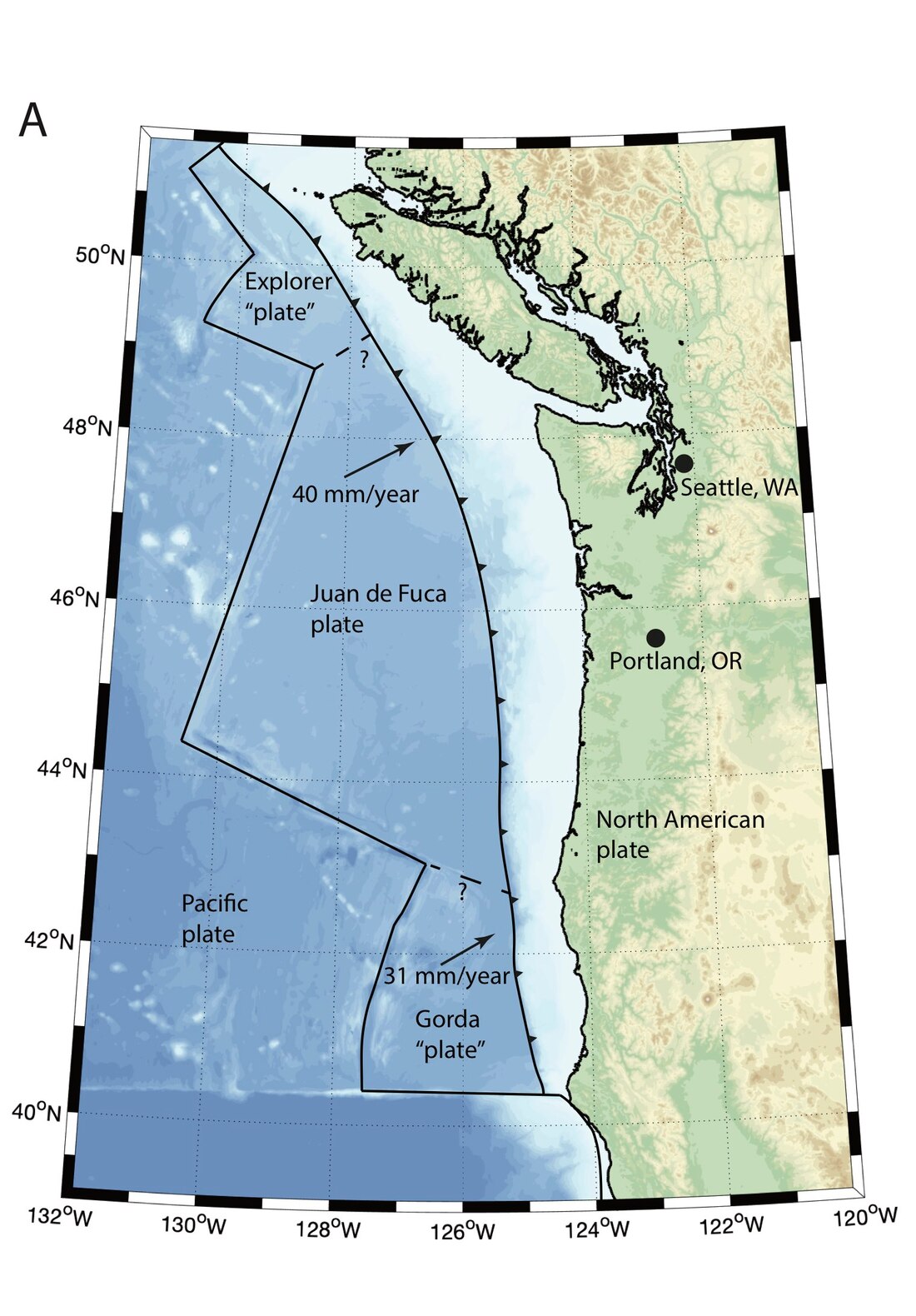
Figure 1. Map showing the Cascadia subduction zone. The Gorda and Explorer “plates” are part of the larger Juan de Fuca tectonic plate, but move in slightly different directions and can be considered sub-plates.
|
Dr. Bartlow developed a new method for separating GPS time series in Cascadia into slow slip and long-term components. These velocities are then inverted for a time-averaged slow slip rate on the plate interface. This is the highest resolution "picture" of the slow slip region in Cascadia to date. There appears to be a gap between the main slow slip zone (Figure 2; rainbow colors) and the strongly coupled zone (Figure 2B; red shading), which implies that slow slip is unlikely to trigger a major earthquake, which would occur in the strongly coupled zone. However, small patches of slow slip slip are found offshore, at the base of the strongly coupled zone. These patches could be very dangerous, and future research will be aimed at confirming their presence offshore.
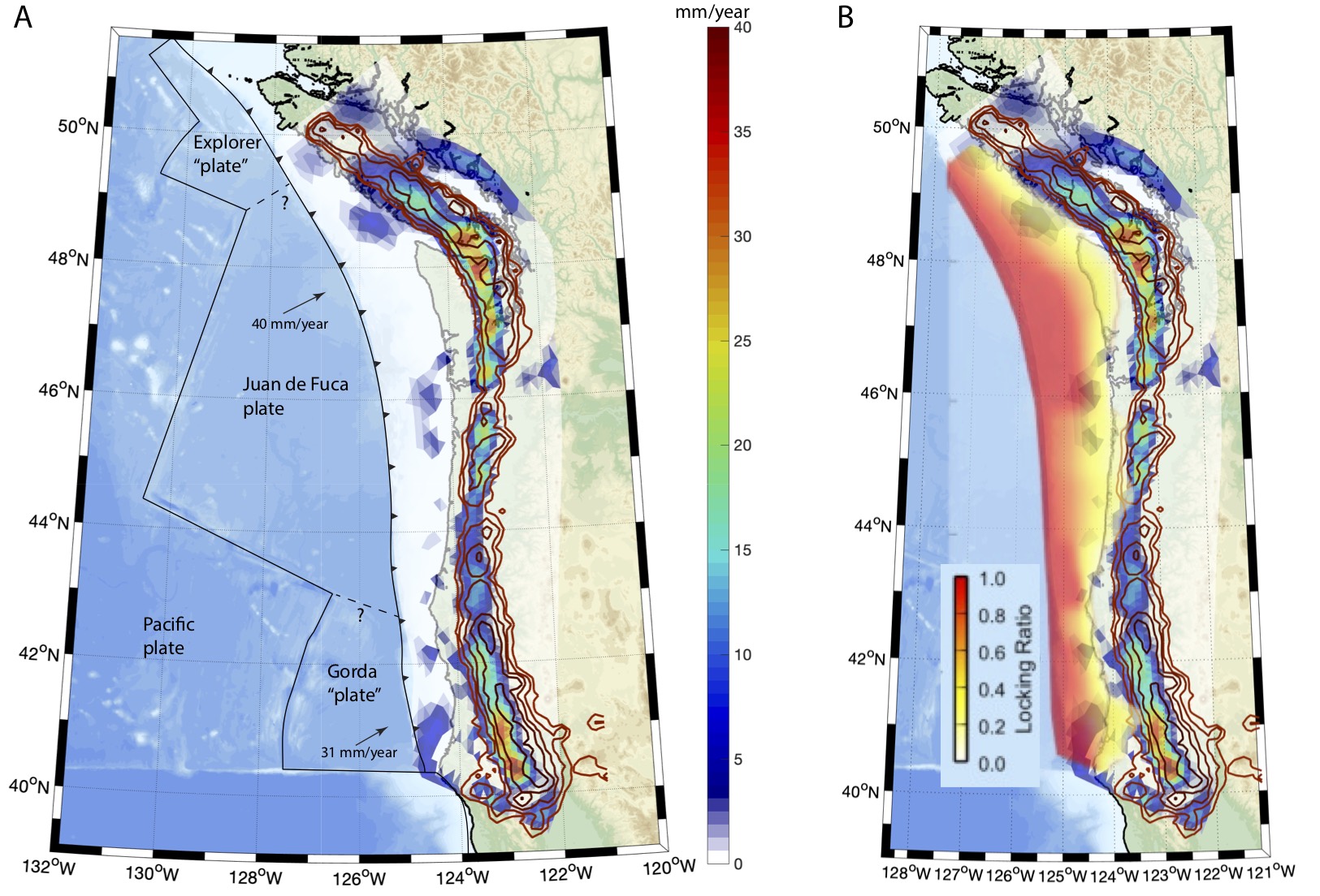
Figure 2. A) Time-averaged slow slip rate (colors) and contours of density of tremor detections (brown lines) on the Cascadia plate interface (modified from Bartlow, 2020). B) Same as A, but with a comparison to the location of the locked zone (red and yellow colors) from Schmalzle et al. (2014).

|
Funding Acknowledgement
This work was supported by a grant from the National Science Foundation's GeoPRISMS program, "Collaborative Research: Improving models of interseismic locking and slow slip events in Cascadia and New Zealand" (award #1551929). |
